Metadata of Atlas Datasets


Using CAM-MeDiA for decision making

The Cambodia Mekong Delta Digital Atlas (also in short called the Atlas or CAM-MeDiA) provides a contemporary knowledge base to support decision making of national and subnational government officials responsible for planning in the Delta and for promoting transitions to more sustainable livelihoods. Unlike its downstream neighbor, Cambodia’s part of the Mekong Delta is less developed in terms of land and water use, rice cropping, and related infrastructure (e.g. low dykes/embankments, sluice gates). However, as Cambodia climbs the development ladder, policies and programs are being set in place, which include potential for irrigation expansion and possible unsustainable land-water use in the Delta. These decisions need to incorporate climate change (precipitation, temperature changes) and associated impacts of drought and flood, as well as impacts of upstream development, such as dams in Laos, and downstream development in Vietnam. Based on this information, it is likely that different solutions would be implemented, such as identifying areas where it is more beneficial to switch from three to two rice crops and/or adopt flood-based agriculture and aquaculture.


Atlas Use Cases Examples


As the government body responsible for planning and management of water resources, the Ministry of Water Resources and Meteorology (MoWRAM) is tasked with overseeing the strategic development and rehabilitation of irrigation infrastructure across the Mekong Delta. MoWRAM's mandate further encompasses water resources monitoring, hydro-meteorological data collection and management; hydrological and meteorological research; and disaster risk management.


"The digital Atlas seeks to improve understanding on the potential consequences of future climate change on infrastructure assets, agriculture and natural ecosystems of the Cambodia Mekong Delta."

ATLAS USE CASE: IRRIGATION INFRASTRUCTURE PLANNING

Irrigation infrastructure planning in the context of climate change

Much of Cambodia's agricultural productivity is constrained by dependence on rainfall, with agricultural areas disconnected from much of the existing irrigation network of canals.

Some 80% of total national rice production is derived from the wet season crop (FAO 2016). The lack of irrigation system capacity across much of Cambodia means that more than 95% of land used to grow rice during the rainy season remains uncultivated during the dry season (Erban & Gorelick 2016). Drought poses a critical hazard to the agricultural sector. The FAO describes the economic consequences of drought in rebuilding livelihoods and protecting lives in Cambodia as substantial (Inter Press Service 2016).

Studies indicate future climate change will lead to intensified agricultural drought in the southern part of the Mekong Basin and flooding across the entire basin (Evers & Pathirana 2018).

An understanding of the provision of irrigation capacity to support agricultural production is central to the mandate of MoWRAM. In support of this aim, the Cambodia Mekong Delta Digital Atlas (CAM-MeDiA) enables the visualization of existing and future planned irrigation canal infrastructure within the context of climate change.

The Atlas enables users to overlay and assess irrigation infrastructure of the Cambodia Mekong Delta in relation to future projected climate change variables (mean change of maximum temperature and mean percentage change in precipitation), and projected future drought and flood.


CAM-MEDIA maps

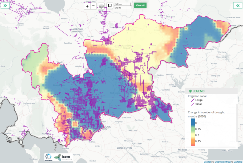
Overlaying of irrigation canals on future projected changes in drought in the 2050s provides insight into the extent of current infrastructure with regard to potential future hotspots of drought risk. For instance, where should investment be prioritized regarding canal rehabilitation and construction? Planning would also require that these data are considered alongside information on projected future land uses (e.g. conservation areas). NOTE: a use case example for conservation area planning is also available as part of the series of fact sheets.

Cambodia Mekong Delta: overlaying of irrigation canal network on projected changes in drought in the 2050s

The Ministry of Environment (MoE) is responsible for conservation of biodiversity, protection of natural resources, and sustainable management of natural resources.
With regard to protected areas management, MoE is tasked with identifying and delineating protected areas (RGC 2008, article 14).


"CAM-MeDiA seeks to improve understanding on the potential consequences of future climate change on infrastructure assets, agriculture and natural ecosystems of the Cambodia Mekong Delta."

ATLAS USE CASE:CONSERVATION AREA PLANNING

Sustaining biodiversity in the context of climate change

Through the 2008 Protected Areas Law and subsequent declaration of Biodiversity Conservation Corridors in 2017, nine types of protected areas are designated within Cambodia: national park, Ramsar site, wildlife sanctuary, biosphere reserve, protected landscape, multi-purpose-use management area, natural heritage site, marine park, and biodiversity conservation corridors (ODC 2017). As of 2017, there were nearly 50 protected areas representing about 40% of Cambodia's total land area.

Protected areas located within the Cambodian Mekong Delta include the Phnom Aural Wildlife Sanctuary, Preah Soramrit-Kosomak "Kirirom" National Park, Southern Cardamom Mountains National Park (eastern fringe only), Boeung Prek Lpeou Protected Landscape, and Koe Seima Wildlife Sanctuary. The latter sanctuary intersects with the eastern part of the delta, whereas all other protected areas are situated in the western delta region, apart from relatively small Boeung Prek Lpeou Protected Landscape located in the southeast corner of Takeo province.

Key Biodiversity Areas (KBAs) further supplement the officially designated protected areas and identify important sites of high biodiversity value.

The future sustainability of biodiversity requires consideration of the potential impacts of future climate change and socio-economic impacts such as those associated with land use changes, and infrastructure development.

Studies indicate future climate change will lead to intensified drought in the southern part of the Mekong Basin and flooding across the entire basin (Evers & Pathirana 2018). Average temperature is projected to increase by 0.79°C across the basin, and precipitation by up to 13.5%, which will be mostly evident during the wet season (Evers & Pathirana 2018).

The Cambodia Mekong Delta Digital Atlas (CAM-MeDiA) provides insight into potential future changes of temperature, precipitation, flood, and drought across the delta. Regarding changes to temperature and precipitation, the Atlas will incorporate three global climate models (GCMs) and display outputs from two scenarios (RCP 4.5 and 8.5) for both the dry and wet seasons.

Using the most up-to-date data and information available, the Atlas can support MoE in assessing the future potential loss of existing protected areas, and opportunities for expanding and developing new sites for conservation.

The Atlas enables users to overlay the existing network of protected areas, and also KBAs and community protected areas over future projected climate change variables (mean change of maximum temperature and mean percentage change in precipitation), and on projected changes in future drought and flood. Such insights will give MoE critical information for guide planning to ensure the conservation of biodiversity across the Cambodia Mekong Delta.


CAM-MEDIA maps

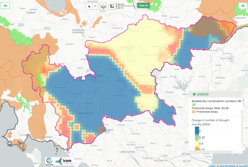
Overlaying areas of high biodiversity value on future projected changes in temperature, precipitation, flood and drought can provide insights into sustaining biodiversity across the delta. In particular, delineation of potential future hotspots of change for climate, flood and drought will enable identification of existing protected areas that are most at risk, and provide valuable information on opportunities to offset possible losses by expanding and developing the protected areas network in other locations.

Cambodia Mekong Delta: overlaying of protected areas network on projected changes in drought months in the 2050s


The Ministry of Agriculture, Forestry and Fisheries (MAFF) is responsible for agricultural planning and development. MAFF contributes to land use policies and natural resources management, and is tasked with monitoring agricultural development activities. The ministry is responsible for providing guidance on the optimal use of agricultural land to improve productivity, including selection of crops, livestock, and soil quality.


"The digital Atlas seeks to improve understanding on the potential consequences of future climate change on infrastructure assets, agriculture and natural ecosystems of the Cambodia Mekong Delta."

ATLAS USE CASE: CLIMATE RESILIENT CROP PLANNING

Crop planning in the context of climate change

Much of Cambodia's agricultural productivity is constrained by dependence on rainfall. Some 80% of total national rice production is derived from the wet season rice crop (FAO 2016). Rain-fed rice is the dominant crop cultivated in the Cambodian Mekong Delta, and other crops which are grown to a lesser extent include cassava, maize, sugar cane and soybeans.

Rice cultivation and the livelihoods of farmers are threatened by both flood, especially during the end of the wet season, and drought.

Drought poses a critical hazard to the agricultural sector. The FAO describes the economic consequences of drought in rebuilding livelihoods and protecting lives in Cambodia as being substantial (Inter Press Service 2016).

Studies indicate future climate change will lead to intensified agricultural drought and flooding in the southern part of the Mekong Basin (Evers & Pathirana 2018). Average temperature is projected to increase by 0.79°C across the basin, and precipitation by up to 13.5% which will be mostly evident during the wet season (Evers & Pathirana 2018).

Climate change can influence rice yields though changes in temperature and precipitation. Rice yield is reduced to zero when soil saturation falls below 30% (ICEM 2013a). Increased temperature has been associated with reduced rice production in a variety of studies (Welch et al. 2010; Luo 2011; ICEM 2013a; Stuecker et al. 2018; IRRI 2020). Increased temperature during the dry season especially threatens production (ICEM 2013a).

A range of factors can influence rice productivity including the rice varieties grown, soil characteristics, cropping patterns and climate (ICEM 2013a p38). Past studies have proved somewhat inconsistent with regard to the impact of climate change on rice productivity in the Mekong Delta, which may relate to a variety of factors including the different climate models and scenarios, and crop productivity models used in the studies (ICEM 2013a). Hydropower development, including that proposed for the mainstream of the Mekong River, poses another critical threat to agricultural and fisheries productivity (Yoshida et al. 2020). Climate change, including increased temperature and altered precipitation regimes (ICEM 2013b), are likely to exacerbate impacts on fisheries caused by hydrological changes from hydropower development (Evers & Pathirana 2018).

The Cambodia Mekong Delta Digital Atlas (CAM-MeDiA) visualizes outputs from past work, and supplements with downscaled (1 km) climate change scenarios derived from global climate models, as identified by the Mekong River Commission as representing the future plausible range of climate variability for the Lower Mekong Basin. CAM-MeDiA enables users to overlay crop patterns, and land use/land cover on future projected climate change variables (mean change of maximum temperature and mean percentage change in precipitation), and projections of future drought and flood.

The Atlas provides an accessible and convenient application for assessing future climate threats in the region. Drought is projected to be variable across the Delta in the 2050s though noticeably prolonged by up to one month in the central region, and also in its western and eastern fringes. Increasing flood depths of up to 3+ m for much of the central region is projected in the 2060s. By the 2060s, during the dry season under RCP 8.5, much of the region will experience temperature rises of ~2°C. Such projected changes will have important consequences for future crop and fisheries productivity, and the livelihoods of farming and fishing communities.


CAM-MEDIA maps

Overlaying areas of high biodiversity value on future projected changes in temperature, precipitation, flood and drought can provide insights into sustaining biodiversity across the delta. In particular, delineation of potential future hotspots of change for climate, flood and drought will enable identification of existing protected areas that are most at risk, and provide valuable information on opportunities to offset possible losses by expanding and developing the protected areas network in other locations.

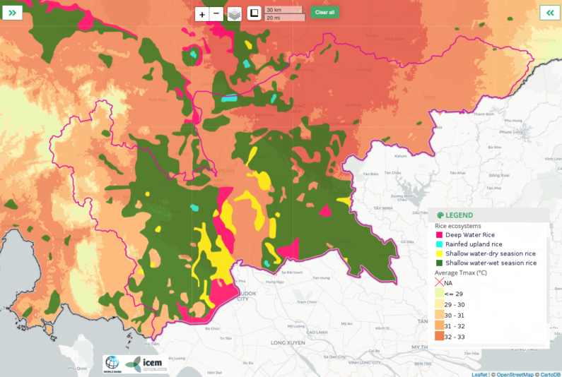
Rice ecosystems (2013) overlain on projected average Tmax in 2030s (RCP 8.5, wet season, 2030s, GCM: IPSL-CM5A-MR).